


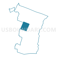
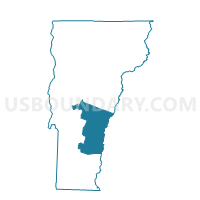
Bridgewater Voting District, Windsor County, Vermont
About
Outline

Summary
| Unique Area Identifier | 680946 |
| Name | Bridgewater Voting District |
| County | Windsor County |
| State | Vermont |
| Area (square miles) | 49.54 |
| Land Area (square miles) | 49.41 |
| Water Area (square miles) | 0.14 |
| % of Land Area | 99.73 |
| % of Water Area | 0.27 |
| Latitude of the Internal Point | 43.64043950 |
| Longtitude of the Internal Point | -72.68982460 |
Maps

Graphs
Select a template below for downloading or customizing gragh for Bridgewater Voting District, Windsor County, Vermont


Neighbors
Neighoring Voting District (by Name) Neighboring Voting District on the Map
- Barnard Voting District, Windsor County, VT
- Killington Voting District, Rutland County, VT
- Plymouth Voting District, Windsor County, VT
- Pomfret Voting District, Windsor County, VT
- Reading Voting District, Windsor County, VT
- Stockbridge Voting District, Windsor County, VT
- Woodstock Voting District, Windsor County, VT
Top 10 Neighboring County Subdivision (by Population) Neighboring County Subdivision on the Map
- Woodstock town, Windsor County, VT (3,048)
- Barnard town, Windsor County, VT (947)
- Bridgewater town, Windsor County, VT (936)
- Pomfret town, Windsor County, VT (904)
- Killington town, Rutland County, VT (811)
- Stockbridge town, Windsor County, VT (736)
- Reading town, Windsor County, VT (666)
- Plymouth town, Windsor County, VT (619)
Top 10 Neighboring Elementary School District (by Population) Neighboring Elementary School District on the Map
- Woodstock School District, VT (3,048)
- Barnard School District, VT (947)
- Bridgewater School District, VT (936)
- Pomfret School District, VT (904)
- Sherburne School District, VT (811)
- Stockbridge School District, VT (736)
- Reading School District, VT (666)
- Plymouth School District, VT (619)
Top 10 Neighboring Secondary School District (by Population) Neighboring Secondary School District on the Map
Top 10 Neighboring State Legislative District Lower Chamber (by Population) Neighboring State Legislative District Lower Chamber on the Map
- Windsor-Rutland-2 State House District, VT (4,451)
- Rutland-Windsor-1 State House District, VT (4,064)
- Windsor-Rutland-1 State House District, VT (3,819)
- Windsor-6-1 State House District, VT (3,811)
- Windsor-5 State House District, VT (3,714)
Top 10 Neighboring State Legislative District Upper Chamber (by Population) Neighboring State Legislative District Upper Chamber on the Map
Top 10 Neighboring 111th Congressional District (by Population) Neighboring 111th Congressional District on the Map
Top 10 Neighboring Census Tract (by Population) Neighboring Census Tract on the Map
- Census Tract 9654, Windsor County, VT (4,089)
- Census Tract 9659, Windsor County, VT (3,320)
- Census Tract 9658, Windsor County, VT (3,048)
- Census Tract 9628, Rutland County, VT (2,926)
Top 10 Neighboring 5-Digit ZIP Code Tabulation Area (by Population) Neighboring 5-Digit ZIP Code Tabulation Area on the Map
- 05091, VT (3,288)
- 05032, VT (2,664)
- 05751, VT (811)
- 05772, VT (713)
- 05062, VT (702)
- 05035, VT (638)
- 05056, VT (567)
- 05034, VT (310)